Is this route really possible?
In recent days, at a quiz on RAI 1, they asserted that a sea route from Pakistan to the Kamchatka peninsula in Russia was possible, right by right without running into any obstacle. I tried to run it with Google Earth PRO, but I couldn’t make one, for every route I enter from Pakistan to Russia, I couldn’t make one that doesn’t avoid passing over the islands.
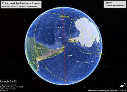
It could be that they intend to “depart from Russia” like departing from the islands of the Andreanof Islands in the Aleutian archipelago in Alaska or crashing into the South Sandwich Islands or Coronation Island.
In short, that you turn it around, from the mainland of Russia, from the northern tip above the Gulf of Ozernoi, in Kamchata up to the other side of the world in Pakistan at Karachi.
It is difficult to be able to make such a route, either due to the difficulty of drawing it on Google Earth PRO, or in the case of a real navigation attempt, due to the fact that it would pass very close to the South Pole and above all under the roaring 50 ° … in short. one should sail among the most dangerous seas in the world. That would be about 19,848 nautical miles.
![The longest straight line: you can sail almost 20,000 miles in a straight line from Pakistan to the Kamchatka Peninsula, Russia. [720x360]](https://www.kleckner.it/stephen/wp-content/uploads/2020/10/The-longest-straight-line-you-can-sail-from-Pakistan-to-the-Kamchatka-Peninsula-Russia-427x214.png)
Try it yourself, some advice
You can do it too, you could try with Google Earth PRO or with a navigation software to make the route and see if the route passes over something, I can give you some advice, to get an easy picture of the situation, you must use the legend of the altitudes and depths, by clicking on show elevation profile, so on the fly you can immediately see if there is a difference in height or a depression, in my case there was always a difference in height of at least 9 meters, which was given precisely by the fact that the route passed above the islands, just off or near the south pole. Also you can use the ruler tool, am when you go to use it, you will find that Google Earth PRO, obviously tries to make the shortest route, so trying to pass above the earth, but if you make a point near Coronation Island, near the pole south, you will be able to break through the pole. Be careful though, we have said that the route must be straight by straight, so without changing the heading … or of course you will have to change it during navigation, now we are not going to explain rhumb line and orthodromia, in short, there must be no angles on the ‘arc that is perhaps between the two points.
And instead it really exists … here is the solution …
I found an article that talks about the kepleronlyknows hypothesis, so called from the name of the user who on December 29, 2012 posted on Reddit the: “longest line that you can navigate on earth without hitting land from Pakistan to the east of Russia “drawing what is called the strange line strange line, strange only because who does not conceive the spherical earth and who does not know the difference between rhumb lines and orthromics. Here you can see the article, know that there is some math to do. https://arxiv.org/pdf/1804.07389.pdf
I leave every consideration to you, but at the bottom of the article it is clearly written: “The authors do not recommend sailing or driving along the found paths.” That is: “the authors are not recommending to sail along this route”
The concept is to start near Las Bela, Pakistan 25 ° 17’00 “N 66 ° 40’00” E, and arrive directly without hitting the ground in 58 ° 37’00 “N 162 ° 14’00” And that it would be Karaginsky District in Kamchatka Krai in Russia. I tried to do it, but in any case I always bump into something …
I also made a video with Google Earth Pro … 🙂
Fonti
Longest Straight Line Paths on Water or Land on the Earth
This Is the Longest Straight Line You Could Sail
The ‘Cooke passage’ : a new world’s longest straight-line sail ?
Allego anche il file .kml che ho trovato http://misoft.online.fr/Marine_GeoGarage/Pakistan_Siberia_GeoGarage.kml
The longest straight line: you can sail almost 20,000 miles in a straight line from Pakistan to the Kamchatka Peninsula, Russia. [720×360]
byu/kepleronlyknows inMapPorn


